Related
Add a Point of Reference (POR) for PRF/Apiculture
Locate and open the PRF or Apiculture policy > Detail Lines tab
Beginning with the 2020 RY, RMA requires that AIPs transmit latitude and longitude for the Points of Reference (PORs) used to establish the Grid ID for PRF and Apiculture.
There are two ways to add lat/long coordinates to a detail line: 1) by selecting the location on a map, 2) adding precise coordinates.
| 1. | Select the Land ID hyperlink in the Land Identifier / Place Name column for the detail line. The Manage Land IDs popup opens and a Select POR button displays above the Land ID grid. |
| 2. | Click Select POR. The Lat/Long map, which displays a map with any fields associated with the Land ID as highlighted, opens. |
NOTE: If fields are not associated with the detail line, you must add them before you can assign a POR. See
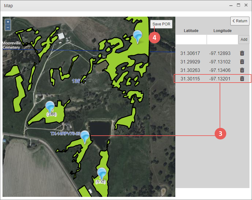
| 3. | Zoom in/pan to identify the location you want to designate as the POR and click on that location on the map to drop a pin. A blue pin displays on the map and the Lat/Long coordinates for the POR display in the fields to the right. |
NOTE: The pin must be placed within the field (Land ID) and Grid ID indicated on the coverage. If not, the System will prompt you to move it or inform you that fields must be created before a POR can be placed.
NOTE: If necessary, you can change the location of the pin by dragging it to the preferred location.
TIP: Hovering over the Lat/Long coordinates for a POR on the right side of the popup will enlarge the pin on the map and change the pin's color to green so you can recognize which pin belongs to what coordinates if more than one pin is present.
| 4. | Click Save POR to save the pin and coordinates. Or, to delete a pin, click the trash icon to the right of the coordinates for the pin. |
To add a pin via Lat/Long coordinates, type the coordinates in the Latitude and Longitude fields and click Add. The manually-created POR coordinates display below the Lat/Long fields.
NOTE: The Lat/Long coordinates must be within the field (Land ID) and Grid ID indicated on the coverage. If not, the System will prompt you to move it or inform you that fields must be created before a POR can be placed.
