Related
At a Glance: The Manage Land IDs Popup
All Reinsurance Years
The Manage Land IDs popup is available from multiple pages within the System. While the Manage Land IDs popup remains the same, the access points vary.
Locate and open a policy > Detail Lines tab > Fast Edit AR button
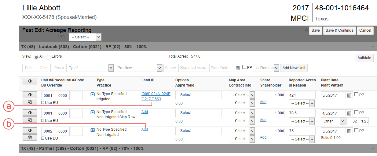
The Land ID column displays a link for opening the Manage Land IDs popup. This link displays differently depending on whether or not Land IDs exist for the detail line:
| a. | If a Land ID already exists for the detail line, the Primary Land ID (i.e., “(009) 024N-024E F: 217, T:563”) displays. Clicking a Land ID hyperlink opens the Manage Land IDs popup. |
| b. | If no Land IDs exist for the detail line, “[Add]” displays. Clicking [Add] opens the Manage Land IDs popup. |
Locate and open a policy > Detail Lines tab > Fast Edit PR button
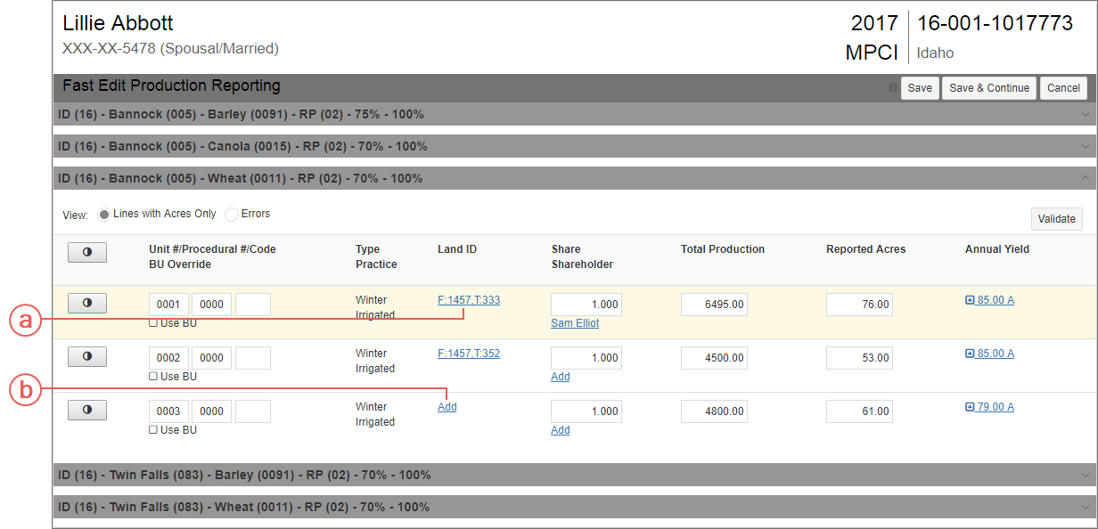
The Land ID cell displays a hyperlink for opening the Manage Land IDs popup. This hyperlink's appearance depends on whether or not Land IDs exist for the detail line:
| a. | If a Land ID already exists for the detail line, the Primary Land ID (i.e., “F:1457, T:352”) displays. Clicking a Land ID hyperlink opens the Manage Land IDs popup. |
| b. | If no Land IDs exist for the detail line, “[Add]” displays. Clicking [Add] opens the Manage Land IDs popup. |
Locate and open a policy > Detail Lines tab > Add button or County link
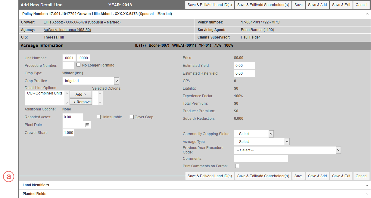
You can access the Manage Land IDs popup from both the Add New Detail Line page and the Maintain Detail Line page; however, the button that opens this popup varies in label and location on each of the pages.
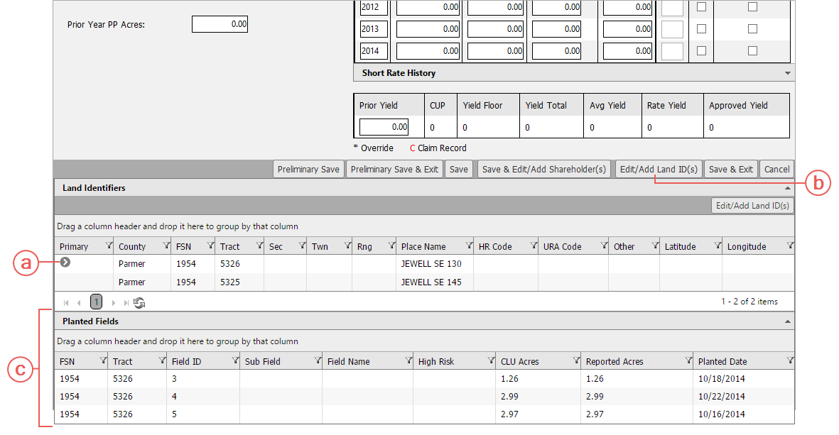
When adding a new detail line on the Add New Detail Line page, a user can also add or edit a Land ID
| a. | After entering, at minimum, the Unit Number, Crop Type, Crop Practice, and Grower Share Percent, click Save & Edit/Add Land ID(s). The Manage Land IDs popup opens with a blank row for adding a Land ID. |
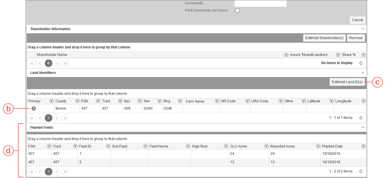
When editing an existing detail line on the Maintain Detail Line page, a user can also add or edit a Land ID
| b. | If there are Land IDs associated with the detail line, they are displayed in the Land Identifiers section. In the previous screenshot, the only Land ID is marked as the Primary Land ID ( ). ). |
| c. | To add or edit Land IDs for the selected detail line, click the Edit/Add Land ID(s) button. The Manage Land IDs popup opens. |
| d. | The Planted Fields section is available below the Land Identifiers section and displays any Planted Fields associated with the Land IDs on the detail line. The Edit/Add Land ID(s) button (shown in “c”) allows for the editing of Land ID and Planted Field information. See "Associate a Planted Field with a Land ID" for more information on Planted Fields. |
Locate and open a policy > Detail Lines tab > App’d Yield link
You can access the Manage Land IDs popup from both the Add and Maintain APH pages. For these pages, the button that opens this popup is the same in label and appearance but in different locations on the pages.
Add APH
Maintain APH
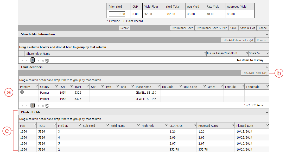
| a. | If a Land ID exists for the detail line, it is displayed in the Land Identifiers grid below the APH. This example shows that the only Land ID as the Primary Land ID, as indicated by the arrow icon ( ). ). |
| b. | To add or edit Land IDs for the selected detail line, click the Edit/Add Land ID(s) button. The Manage Land IDs popup opens, displaying any existing Land IDs if present. |
| c. | The Planted Fields section is available below the Land Identifiers section and displays any Planted Fields associated with the Land IDs on the detail line. The Edit/Add Land ID(s) button (shown in “b”) allows for the editing of Land ID and Planted Field information. See "Associate a Planted Field with a Land ID" for more information on Planted Fields. |
Locate and open a policy > Detail Lines tab
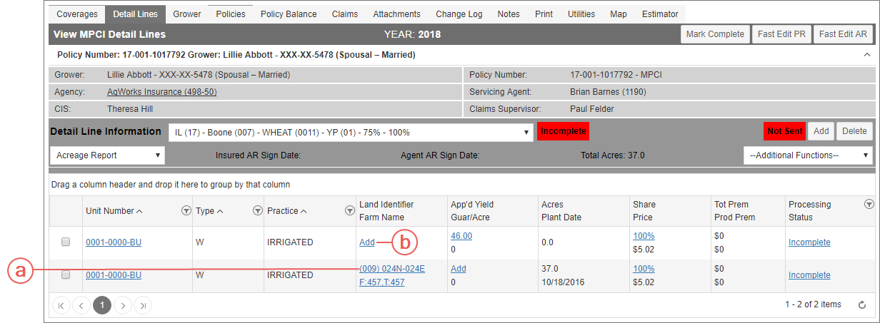
The Land Identifier/Farm Name column displays a link for opening the Manage Land IDs popup. This link displays differently depending on whether or not Land IDs exist for the detail line:
| a. | Displays the Primary Land ID and Place Name (e.g., “(009) 024N 024E F:457, T:457”) designated for the detail line. Clicking a Land ID opens the Manage Land IDs popup. |
| b. | Displays as “[Add]” if no Land IDs exist for the detail line. Clicking [Add] opens the Manage Land IDs popup. |
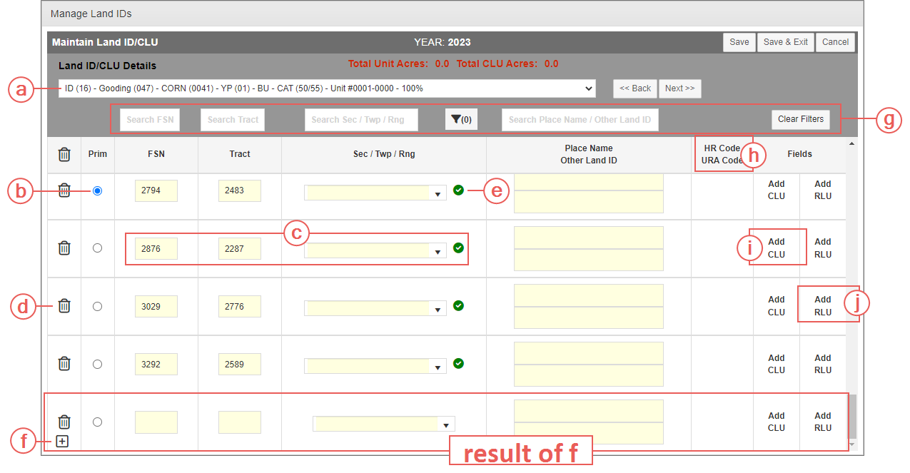
To enable users to add Land IDs easily within the System, a popup, Manage Land IDs, was added. The following breaks down its different components.
| a. | Detail Line header:Displays the Policy State Abbreviation and Code, Policy County Name and Code, Crop Name and Code, Crop Plan and Code, Coverage Level, Price Election Percent, Unit Number (includes Basic Unit#, Optional Unit #, Procedure #, and Procedure Code—if applicable); Type and Code, Practice and Code, and Grower Share Percent. |
| b. | Primary Land ID indicator: Indicates that the Land ID displayed in the corresponding row is the Primary Land ID for the detail line. This is the default Land ID displayed on various pages and forms found in the System. Only one Land ID per detail line can be designated as the Primary Land ID. By default, the first Land ID record found in the database for the detail line is the one designated as the primary; however, the user can change the Primary Land ID as needed. See "Designate a Primary Land ID". |
| c. | Validation Indicator: The System automatically validate FSN, or FSN/Tract, and/or Section/Township/Range, FSN, or FSN/Tract, and/or Section/Township/Range against data provided by the RMA via the CLU Web Service. |
| If the FSN or FSN/Tract and/or Section/Township/Range are valid, a green checkmark appears in the Validate column for the corresponding Land ID. If the System cannot validate the Land ID, a red X appears instead. To learn why a Land ID could not be validated, hover over the validation icon to view the explanation as a tool tip. |
| d. | Land IDs: The FSN and Tract fields and the Sec/Twn/Rng dropdown make up the Land IDs for the detail line. The FSN and Tract fields allow a user to enter or edit the FSN and Tract number, respectively, for the Land ID, using up to 7 characters for each. The Sec/Twn/Rng dropdown allows for both text entry and selection from the dropdown. The dropdown is populated with valid Section/Township/Range combinations found for the FSN or FSN and Tract applied to the Land ID record. |
| e. | Delete button: Deletes, when clicked, the corresponding Land ID from the detail line. However, a popup will prompt the user to confirm the deletion if there are also Planted Fields associated with the selected Land ID. Users may delete ALL Land IDs for the detail line by selecting the delete icon in the column heading. A confirmation of the delete will be required. |
| f. | Add New Land ID: Allows a user to add a new Land ID to the selected detail line (shown in the Detail Line header). Click the button opens a new row. |
| g. | Search: Filters the land IDs shown in the grid by FSN, Tract, Section/Township/Range, Validation Status Message, or Place Name/Other Land ID. Type, or when appropriate, select the desired criteria in one of these new search fields, and the available matches will display. |
| h. | HR Code & URA Code |
| HR Code: Displays, if applicable, the High Risk (HR) Code found on the HR Land table for the Land ID. The System will determine the code at save of a Land ID record based on Section/Township/Range/County/Crop/Type/Practice/Map Area. These HR Codes and their descriptions are displayed upon hovering over HR Code label in the column header: |
| • | C: Indicates the Land ID is fully located within the map area (may or may not be High Risk), |
| • | H: Indicates the Land ID is completely located in a High Risk Map Area, |
| • | P: Indicates the Land ID is located in a Partial High Risk Area, or |
| • | V: Indicates the Land ID has been verified to not be located in a High Risk Map Area. |
| URA Code : Displays, if applicable, the Unrated Sub County Code (URA) found on the PLSS table for the Land ID and that same Sub County Code is in the Map ADM table for the Crop/Type/Practice. The System will determine the code at save of the Land ID record based on the State/County. One of these two codes may display: |
| • | C: For completely covered by Map Area, or |
| • | P: For partially covered by Map Area. |
| i. | Add CLU: Opens a Planted Fields row directly below the Land ID it coordinates with so that Planted Fields can be associated with the Land ID. As CLU acres are added, the CLU acres sum at the top of the popup will update. |
| j. | Add RLU: Opens a row directly below the Land ID it coordinates with that resource land units can be associated with the Land ID. |
| k. | Map: (not shown) Opens a map displaying all fields for the FSN/Tract from the Land ID record. This link is only visible when valid FSN is on the land ID. On the map, selected fields are shaded darker than those not selected. The user can zoom in and out, apply layers, and click to select the planted fields to associate with the Land ID. |
